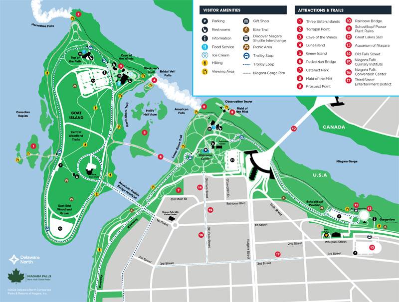
Niagara Falls State Park Map
Get the lay of the land with our Niagara Falls State Park Map. You may also download and print a copy to take with you.
Downloadable map is in PDF format. Requires Adobe® Reader®

Click the map above to view a larger version. PDF - requires Adobe® Reader®
Here are some popular trails in the area that will lead you to Niagara Falls' most scenic and impressive locations!
Goat Island Trail
The Goat Island Trail brings you to historic Goat Island and there you can visit Luna Island, Cave of the Winds, Terrapin Point, Top of the Falls Restaurant, and Three Sisters Islands. It's a 10-minute walk to the bridge, but then take as long as you wish to explore. Goat Island is also accessible by the Niagara Scenic Trolley.
Lower River Trail
The Lower River Trail will bring you to Prospect Point, Maid of the Mist, the Schoellkopf Power Plant Ruins, the Aquarium of Niagara, and the trailhead to the Niagara Gorge Trails! An easy stroll of about 10 minutes will get you there.
Downtown Niagara Falls USA Trail
The Downtown Niagara Falls USA Trail will highlight all there is to do, see, and eat outside of the Park. You can access the Niagara Falls Culinary Institute, the Niagara Falls Convention Center, the Seneca Niagara Casino and the Third Street Entertainment District, as well as many hotels, eateries, and bars. 15 miles.